


Guanacaste Maps

Map of Guanacaste and the Nicoya Peninsula and the current coastal road route. When a bridge is constructed over the Montana River, the coastal road which is in the process of being completely paved, will run contiguous to Hidden Beaches of Nosara (HBON). HBON is shown inside the red circle.

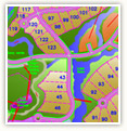
This Map of Nosara shows various accomodations, restaurants, bars, public facilities and area shopping in and around Nosara. Hidden Beaches of Nosara is north of the Rio Nosara and is outlined in red.

This map shows the projected Costa Rica Population Density 1984-2010. The greater Nosara area which includes Hidden Beaches of Nosara and its projected population density are indicated with red arrows.
Interactive Map
Click here to view our interactive map with detailed information on all phases of Playas Escondidas Nosara
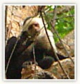
Explore Paradise
Click here to visit our extensive photo gallery of the property and surrounding areas, wildlife, and vegetation.